/https%3A%2F%2Fwww.kukkolaforsen.se%2Fwp-content%2Fuploads%2Fflags%2FUK.jpg)
/https%3A%2F%2Fwww.kukkolaforsen.se%2Fwp-content%2Fuploads%2Fflags%2FFinland.jpg)
/https%3A%2F%2Fwww.kukkolaforsen.se%2Fwp-content%2Fuploads%2Fflags%2FSweden.jpg)
/https%3A%2F%2Fwww.kukkolaforsen.se%2Fwp-content%2Fuploads%2F2023%2F10%2Fcollgae-kukkolaforsen-till-facebook-scaled.jpg)
Summertime exploration!
0 – 15 km
In Kukkolaforsen Cultural Village you can wander around and learn about the people, fishing, and the importance of the river. Explore different buildings and see objects in their natural environment. Visit two water-powered mills, a sawmill, and an old miller’s house. In summer we demonstrate some of the old machines. Don’t miss the fishing museum, art exhibitions, and pop-up shops.
Exercise trail: About 4 km north of Kukkolaforsen there is an exercise trail with 3 and 5 km loops. The 3 km loop is electrically lit and has ski tracks in winter. Google Maps-länk
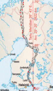
World Heritage Struve Meridian Arc: Consists of 265 measurement points along a 2 820 km stretch. The measurements proved that the Earth is oval, not round. The World Heritage Site is about 7 km from our site. Google Maps-link. Read more at Unesco.
Elmers farm: A charming farm shop with the farm’s own products such as rapeseed oil and mustard. Here you will also find food crafts and handicrafts from Norrbotten and Tornedalen. Google Maps-link
Karungi village: A historic village with a railway station that was a hub during the First World War. Visit the Karl Gustav Church and enjoy beautiful views. Facebook-page
Tervajänkke: Ett naturreservat där du kan vandra och titta på fåglar. Här häckar bland annat dvärgmås och lärkfalk. Länsstyrelsens webbplats
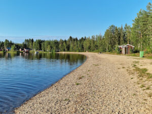
Karsikojärvi swimming area: A quiet, family-friendly beach with changing facilities and a section of beach for use by dogs. Google Maps-länk
Pitkäjärvi birdwatching tower: There is a birdwatching tower at Lake Pitkäjärvi, about 3.7 kilometres from the 99 road onto Björkforsvägen. Google Maps-link
Saivara stone-age village: One of the largest and most interesting Stone Age settlements in the Barents region. Near Kärrbäck, on road 356 in Haparanda municipality. Google Maps-link
Leipijärvi swimming area: A small, family-friendly beach. Google Maps-link
Myllyjärvi barbecue area: A nice barbecue area by a small lake. You can drive all the way there. Google Maps-link
15 – 40 km
Matkakoski: An important old fishing spot at Korpikylä. The villagers have traditionally fished here for whitefish, salmon, and lampry. Follow road 99 northwards from Haparanda for about 37 km, and turn right towards Matkakoski. Google Maps-link
Björkfors: A historically rich village with Norrbotten’s first sawmill, dairy, and telephone line. Google Maps-link
Haparanda City: Founded in 1621 by Gustav II Adolf. The city has an exciting history and was an important hub during the First World War. Find out more at Haparanda/Tornio web page
Tornio Stad: Vår tvillingstad. Torneås historia började med att Svensarö i Torne älvs mynning bebyggdes. Gustav II Adolf lät Olof Bure planera staden 1620, och dagens gatunät härstammar från hans arbete. Efter att ryssarna brände ner staden på 1700-talet, förlängde Hans Kruse huvudgatan och lade till en ny huvudgata.. Läs mer på Haparanda/Tornio web page
Tornedalens museum: Tornedalens museum presenterar den Tornedalska kulturen och historien sedd ur både ett finskt men även svenskt perspektiv. Under 2014 utvidgade muséet sitt verksamhetsområde och blev därmed ett gemensamt museum för gränsstäderna Haparanda och Torneå. Läs mer på Tornedalens museum
/https%3A%2F%2Fwww.kukkolaforsen.se%2Fwp-content%2Fuploads%2F2025%2F05%2F20240727_085515-scaled-e1747735674182.jpg)
/https%3A%2F%2Fwww.kukkolaforsen.se%2Fwp-content%2Fuploads%2F2024%2F05%2Futsiktsrestaurang.jpg)
/https%3A%2F%2Fwww.kukkolaforsen.se%2Fwp-content%2Fuploads%2F2023%2F10%2FAvkoppling-i-Hot-tuben.jpg)